CoastalShield for Miami-Dade
A GIS-based coastal risk platform that turns scattered seawall and pier records into a live map of weak segments so DEM and EOC teams know where failures are most likely in the next storm.
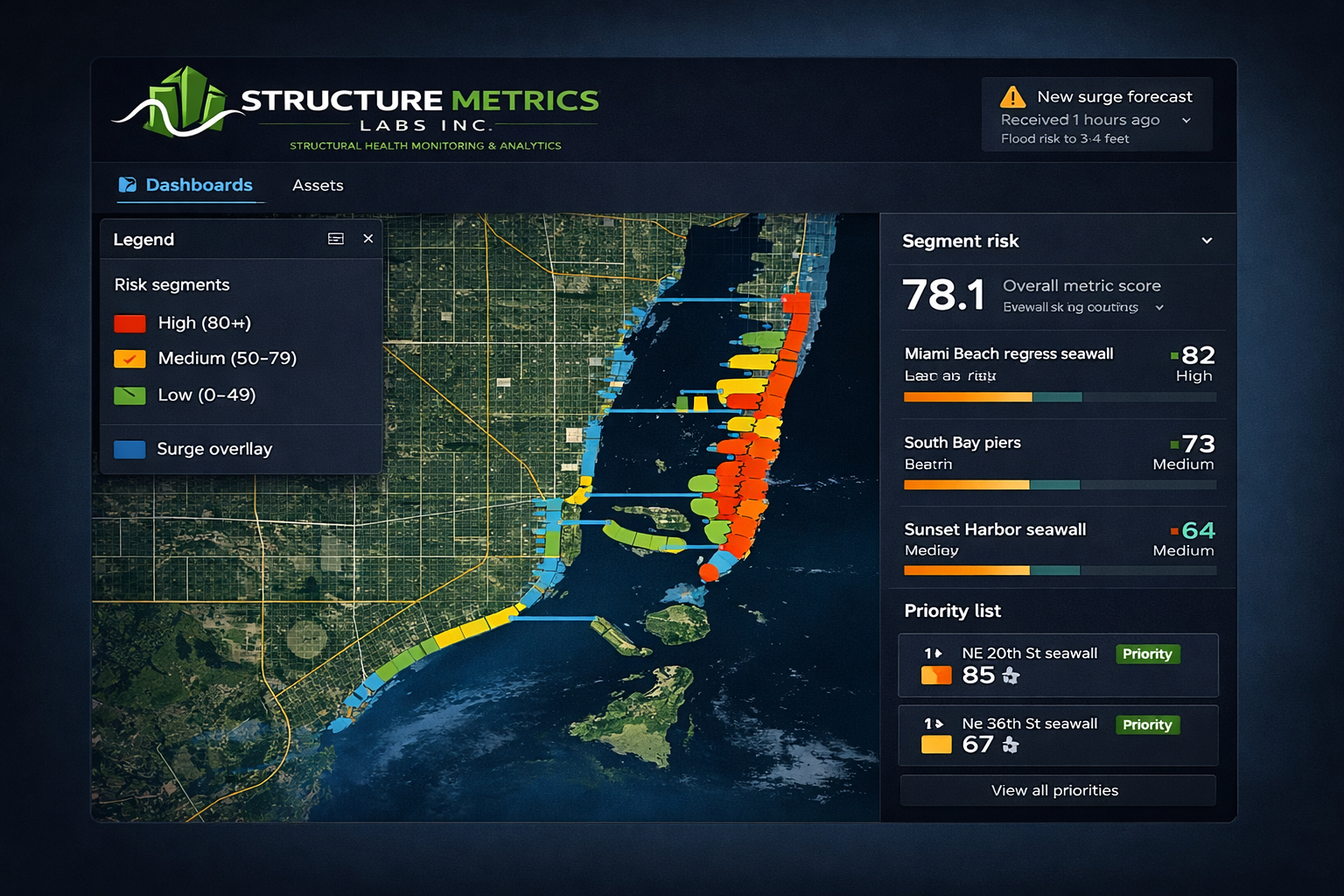
DEM can’t see weak points until they fail
Miami-Dade’s seawalls and piers were built at different times and standards. Condition information is scattered across PDFs, inspection reports, photos, and departments, so DEM doesn’t have a real-time view of weak coastal segments before king tides or hurricanes.
A coastal risk dashboard for DEM and EOC
CoastalShield is a GIS-based platform that maps all existing seawalls and piers, scores their storm failure risk, and gives DEM/EOC teams a live coastal risk dashboard to prioritize inspections and mitigation.
- Coastal asset registry and map of seawalls/piers.
- Risk scoring that combines condition, exposure, and surge/tide data.
- Dashboards and alerts tailored to DEM/EOC workflows.
From scattered records to a live coastal map
CoastalShield ingests existing County data first, then layers on analytics and optional retrofit sensors where needed.
Inputs
- Asset and inspection records from existing systems.
- Photos, drawings, and GIS layers.
- Tide and surge forecasts, elevation, and exposure data.
- Optional low-power sensors (tilt, water level, corrosion) for critical segments.
Outputs
- Risk maps with segment-level scores.
- Priority lists for inspections and mitigation projects.
- Dashboards and alerts for DEM/EOC operations.
Suggested pilot with Miami-Dade
Start with 1–2 coastal neighborhoods or a specific seawall corridor. Ingest existing asset and inspection data, create the initial risk map.
Use the dashboard during king tides or one storm season, refine scoring with DEM/Public Works feedback.
Coastal asset map, segment risk scores, EOC dashboards, and a scaling plan for the full coastline.
Technology and security
Browser-based and integration-ready
Cloud-hosted, browser-based platform that integrates with existing County GIS and data systems.
Start with the data you already have
Can start with existing data and later incorporate low-power retrofit sensors where needed.
Aligned to County requirements
Role-based access, SSO-ready, and encrypted in transit (HTTPS/TLS) to align with County security requirements.
Team
CoastalShield is being developed by Structure Metrics Labs, a small team combining structural health monitoring, data science, cybersecurity, and platform engineering.
Let's protect Miami-Dade's coastline together
If you work on emergency management, coastal resilience, or public works and would like to explore a pilot of CoastalShield, we'd love to talk.
From fragmented records to operational coastal visibility
CoastalShield helps agencies move from scattered documentation to a shared, storm-ready view of vulnerable coastal segments.